Rembrandt,
Van Gogh, windmills, canals
—this is
what comes to mind for many when thinking of visiting Netherlands. Me, too until now.
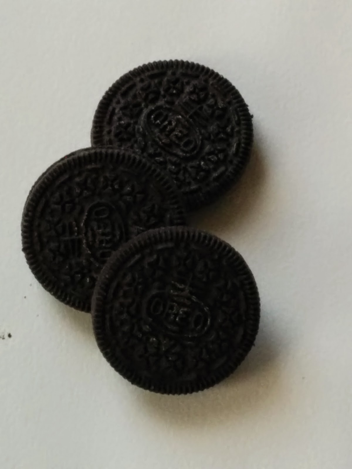

But--Oreo
Cookies? I have now come to understand
that Holland, specifically Wormerveer and Zanse Schans in Zaanstadt, where we
are staying, is the center of the universe for the chocolate that is used for
Oreo cookies. No Holland, no Oreos. What a fate.
I would have come here to worship at the center long ago, had I
understood.
In our cozy
apartment facing the Zaan River, we look out at a cocoa factory with barges
delivering beans which are scooped up into a hopper which must convey them into
the factory. When we go outside, we
smell chocolate. We visited the windmill
village of Zanse Schans, a hop down the river, to tour the restored mills which
are the few that remain from the 1000 which powered the first industrial
society in the 16th C. One of
them grinds chocolate for the de Zaan Company which makes the Oreo chocolate—I have
almost finished my souvenir jar making hot chocolate. I have finished my Oreos which they sell here
but in kind of tiny packages. The
consumption of Oreos must depend on the American consumer market. I am definitely doing my part, though, during
our 2 week stay.
We have
bonded with our little neighborhood which is a mix of light industry, boats and
houses. Dutch have really big windows right
on the street, often with light lace curtains.
So we and our neighbors become a bit familiar with each other. We love watching the people who live on the
barges delivering cocoa beans. One
family has the most beautiful golden retrievers who get walks every evening and spend the day sunning on the deck. All the barges have lace curtains in the
windows, just like the houses on our side.
We have
spent our tourism days in Amsterdam enjoying the city immensely. We have taken full advantage of the trams as
sightseeing tours. Rembrandt House was
even offering etching classes and we made prints. (I guess it will come as no surprise that
Rembrandt was better than I am at the art.)
Van Gogh museum is such a pleasure.
There are so many paintings that we can really see his development of
style. He made such lovely paintings
which are uplifting, create feelings of happiness while himself suffered such
despair. A concert by the Royal Concertgebouw
Orchestra presented early 20 C. music which was challenging to absorb—I am glad
I had Van Gogh in my minds-eye while the music was in my ears. The sincere
little dog at the English Bookstore was as restorative as the coffee and books.
As we hoped,
staying outside of town in a quieter location was a good idea. We have biked around, walked, bussed and
taken trains into town. Although we are
in an area which is now an open air museum—Zanse Schans for the windmills—and a
large natural area—De Poel Borerderij Wormer, this area was the first heart of
industrial Holland in the late 15th C. So there is much of interest in a peaceful
location. Our cozy apartment is in The
Heritage B&B (www.theheritage.nl; anankejapp@gmail.com). We recommend them highly for anyone spending
a few days in the Amsterdam area.
 |
| Our way of moving around |
Amsterdam
itself was empty marsh until about 1200 but here we find habitation from about
700 BC. Getting lost has its uses—we took
the wrong train home from Amsterdam and ended up having to reverse course at
Uitgeest. (Well, it is funny now but at
the time we were a little cranky.) But a
little research leads us to understand that the whole area from Uitgeest to Zaandam
was inhabited from 1000 or 700 BC. When
the Romans controlled southern Netherlands and the Rhine Valley, the farmers of
this area prospered by trading with them.
To our delight, the nature center offered an archeology tour so we could
get a better sense of the local area.
Sunny day, boat trip, local families and the local archeologist—about as
good as it gets for the likes of us.
Piet Kleij
is the Zaanstad State Archeologist (and aren’t we delighted that there is such
a position!) so he knows the local stuff thoroughly. A Roman coin was found a few days ago in the
north part of the area. Imagine! I love that.
We also enjoyed reading a history of specifically Amsterdam by Geert
Mak. Our guide, Piet and our author Geert,
help make some sense of the fascinating ebb and flow of water and people of
this area.
As Piet
explains the timeline, this area was populated by migrants from the dunes area
on the coast (30 miles away, maybe). The
area was a bit drier at the time and the Frisian people who farmed all over the
area extended into this vicinity around 700 BC.
I think I have it right that there was some earlier habitation of
similar farmers from around 2000 BC who withdrew when the climate cooled and the higher water table prevented
farming. Stone henge experienced a similar population and cultural decline around the same time. There is evidence that culturally related people came to this area to hunt and fish. Their descendants then returned to farm in 700. The style, placement and products of their
farms, the way and where they dug drainage canals, consistent place names from
the earliest recorded history show that the generally same ethnic group lived
here during the entire period from about 700 BC to more or less now. However, within this continuity, there is
adjustment to the climate cycles and the economic vagaries of the wider
world.
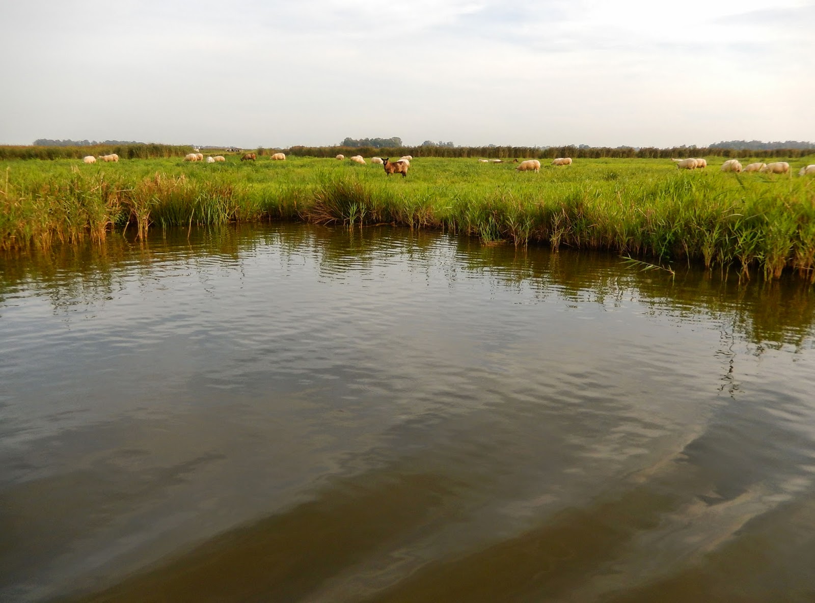
The farmers
of the area grew grain, raised cattle and sheep, mainly as subsistence
farmers. As the water table changed,
they could not grow fruits and vegetables any more so began to make cheese to
trade nearby for cash or other food. The
Romans had a fort nearby but were not successful in actually conquering the
general area. Nevertheless, the farmers
thrived by selling leather, meat and other farm products for Roman use and for
trade to other areas of Europe. A Roman coin was discovered in the northern
part of the area just a few days ago. After the Roman Empire collapsed around
400 AD or so, the area lost all its population and there is not even evidence
of hunting or fishing. Well, we know the
whole continent lost population—we see that here too. No signs of many deaths from disease,
starvation or warfare—people just left.
 |
| Wormer--still a long skinny town |
 |
| Wormer-close-up. One of the last surviving windmills. |
The same
kind of farmers moved back in around 700-800 AD. They used the same place names--Jisp is on one end of our lake and was noted by the Romans by the same name, The physical
pattern of their farms was similar. As
they increased in numbers, they drained land and build towns in single lines
along the highest ground, the dikes. Wormer, the next town, is one of those
long skinny towns. As water was pumped out the land sank and they lost enough land that they had to devise a creative
response to survive. They became fishermen.
Well they always fished, now they fished more, farmed less. “Too much water. Can’t farm—better fish. Fishing—hmmm… Let’s build better boats. Let's go far away and find herring and whales.”
My take-away
on this is that we have a people adjusting to rather rapidly changing physical
and economic circumstances. There appears
to be enough continuity and security for stable cultural patterns but enough
stress to push the folks into inventive ways to carry on. They invented the world’s first industrial
society by taking just the next step and the next step to manage their watery
circumstances. They have given many gifts to the world through their inventiveness.
The Zaan River
area may be the Saudi Arabia of wind. It
is definitely the first use of power on an industrial scale. These fishermen had continued to exploit their
situation by improving their boats, extending the range of where they could
travel and making better sailcloth. They
harnessed the power of the wind. TA DA!—windmills.
Some local smart guy figured out how to
saw lumber with windmills thus making better and cheaper boats. Similarly, spinning and weaving sail cloth,
making ropes. Then when the fishers were
catching whales, they brought them here to extract the oil and other
products. It is the first industrial
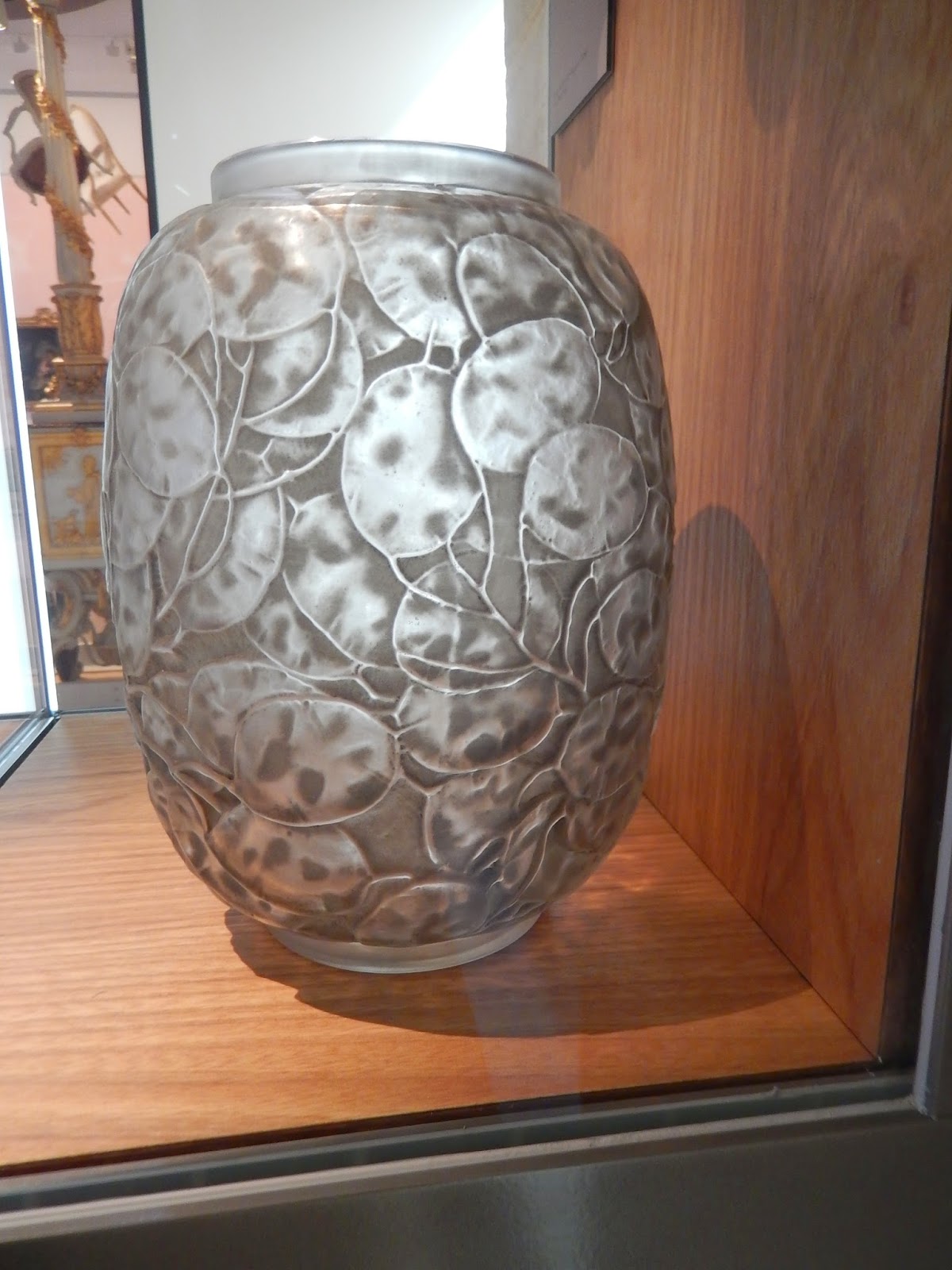
area on earth and was an incredibly prosperous and sophisticated place. Our boat passed areas where everything from
Roman cloth to a very fine Majolica vase have been found. Massive dumps of whalebone remain from the
whaling era. Clothing, pottery and other
artifacts from every part of the world—including Niewe Amsterdam—has been found
within our little catchment area.
Fishing and
whaling tanked—over fishing mainly.
England got better at building boats.
The economy spiraled down. It
took these guys, now including Amsterdam, a while to pull themselves back up
but they did, finally. Our little area,
though, was no longer the center. Water
courses changed and industry moved over to the actual river. More land has been drained, farming thrives
but the first industrial area is now a nature center—thus our riverside cocoa
factory and a related factory which makes the liquid that chocolate is made
from. Now the former industrial lake is a
center for wintering waterfowl and spring breeding shorebirds giving me some
great birdwatching with a local birding pal. The white-fronted geese are arriving for the winter. But the smart guys around here who
know much about the management of water and taking advantage of climate change
have a bright future as the rest of us need their skills. Maybe the next big thing.
 |
| Birdwatching with apple pie |
We are
noticing that we don’t much like leaving after we have been somewhere for a
while. Among other things, we have some
very odd meals as we are finishing everything we bought. Tomorrow we are off to northern Spain but we need
to have continued reports about the golden retrievers. And we are wondering about the guys who were
working on the neighboring roof in London and whether anything is blooming in Gary’s garden. The Clement V bakery in Etretat—we just got
it figured out that they delivered bread to our campground and we’re gone. Our
slow travel might not even be slow enough after all.