 |
| Walking in Burren National Park Deforestation is a souvenir from prehistory |
People have been living in this area of western Ireland for thousands of years. Their remnants are all around, and we went all around to look at them. I'll share what we found, hopefully in a more or less clear fashion. I'm actually kind of shoddy with dates, so I am cribbing from Hugh Carthy's wonderful Burren Archaeology: A Tour Guide, so I don't go too far astray.
There are three main periods of Irish history in the west, prehistoric (up to about 500 BC), medieval (500 AD up to about 1700), and modern (which means since 1700). These are rough dates, as you may suppose, because it's hard to date rocks using carbon-14 technology (no carbon in those rocks) so just bear with me.
I'll start with prehistoric. This mainly means Neolithic, which means after farming was invented, but before people started using metal tools. They were still using stone for tools. Plenty of that around here.
However, even before farming, people were here, as hunter-gatherers. There was a tool workshop for making stone arrow heads, scrapers, and axes, on the beach where the river through Doolin joins the Atlantic. There are useful-looking rocks on that beach, and flakes and tool-making debris were found there. Nobody knows the dates of the tool-making, however. These days there's a hiking trail on far side, and on the near side, a pasture as well as a little golf course.
The hunter-gatherers left very few traces of themselves, so, moving right along, we come to the first farmers, starting about 6,000 years ago. Neolithic people lived in houses, grew crops, herded cattle and sheep and goats, and built stone enclosures and graveyards. They built stone walls, oh, so many walls! You can't believe the labor that has gone into wall-building over the centuries, and it started right with these earliest farmers. To get the rocks out of the fields, they made miles of stone walls. A shocking amount of heavy labor went into those walls.
I'll start with prehistoric. This mainly means Neolithic, which means after farming was invented, but before people started using metal tools. They were still using stone for tools. Plenty of that around here.
However, even before farming, people were here, as hunter-gatherers. There was a tool workshop for making stone arrow heads, scrapers, and axes, on the beach where the river through Doolin joins the Atlantic. There are useful-looking rocks on that beach, and flakes and tool-making debris were found there. Nobody knows the dates of the tool-making, however. These days there's a hiking trail on far side, and on the near side, a pasture as well as a little golf course.
 |
| Mouth of the Aille River at Doolin. Can't see the river which is below the near cliff. Rocks formerly used for stone-age tool making on this stony beach. |
The hunter-gatherers left very few traces of themselves, so, moving right along, we come to the first farmers, starting about 6,000 years ago. Neolithic people lived in houses, grew crops, herded cattle and sheep and goats, and built stone enclosures and graveyards. They built stone walls, oh, so many walls! You can't believe the labor that has gone into wall-building over the centuries, and it started right with these earliest farmers. To get the rocks out of the fields, they made miles of stone walls. A shocking amount of heavy labor went into those walls.
The oldest walls are long broken down and overlaid with other walls. But looking from the air, it's possible to see them still in the landscape.
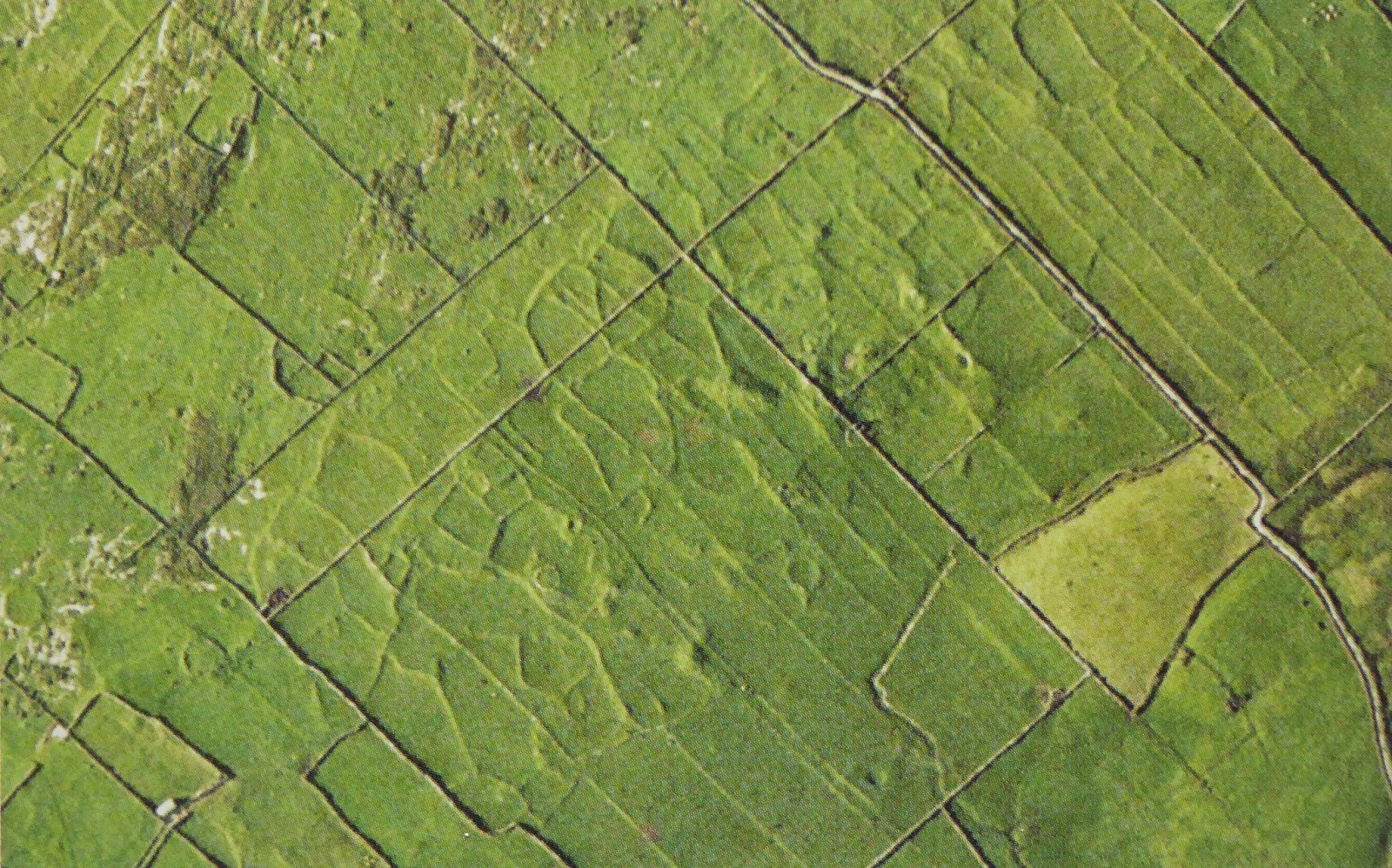 |
| Part of the Glasha Group of field walls, from Ordnance Survey Ireland Credit: Hugh Carthy, Burren Archaeology: A Tour Guide, 2011 |
The Glasha Group is almost directly across the road from where we're staying here in Doolin. It was great to get this photo, since from the ground you can barely see the faint shadows of the old walls. They're very clear from the air, though. The long straight lines are the modern walls, and the shallow, shadowy lines are where the pre-historic walls used to be. The squiggly, wandering lines are likely early, the long parallel lines later in the domestication of the land.
When farming began in western Ireland, the rock that is now the Burren was covered with soil and forests. Forests of oak and elm made heavy work to log off in the lowlands, but in the uplands pine and hazelwood were more common. These proved easier to clear, so much early settlement was in the higher regions. The growing season was longer than now, as temperatures were higher by a couple degrees at that time.
Creating a settled farming system based on linear fields separated by stone walls might have taken about 500 years. They built up communities, developed ritual life, engaged in long-distance trade. A beautiful stone ax was found in a grave from this period, of stone from northern Italy. Trade probably sparked the development of Bronze Age technology in Ireland, too.
So now we are talking about the same people, but with a more complicated technology. The Stone Age waned and the Bronze Age began. Society became more hierarchical, with some people having more power than others, a stratification that carried into the visible remains.
Anyway, while society was becoming more complex, climate change was going on at the same time. Ireland became cooler and much wetter. It wasn't just Ireland - a large change in the climate took place all over Europe.
In western Ireland the loss of tree cover in the uplands had already led to erosion of the thin soil. In heavier rains the earth slid right off the rocks that lay just underneath, leaving bare stone. In flatter landscapes, grasslands became bogs.
The dramatic landscape now called the Burren came about at that time. Now it's a tourist attraction, but for those Bronze Age farmers it was a disaster. The population fell, as the uplands were abandoned. Stone walls were not built for a thousand years. Other parts of Ireland, including the Aran Islands, became more important than the Burren.

Still so bare? Well, today's sheep and cattle keep the brush and trees down, fostering grasses and wildflowers. Where they don't graze, brush and small trees come back. If the farmers stop pasturing their cattle in the uplands the Burren will revert to brush. You can see it happening a bit in the pictures above. Actually there are some areas (but not in the parkland in the pictures) where thorn bushes and gorse are the principal greenery now. Although we could make out something of the ancient walls, some of the land seems essentially abandoned to wilderness.
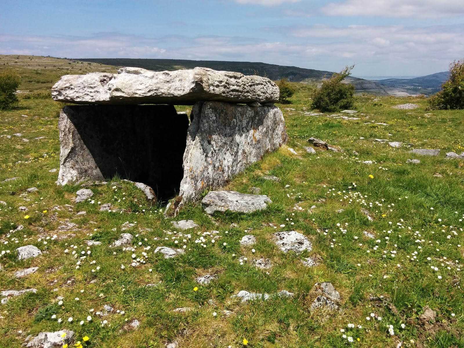
Besides the rocky Burren itself, and the miles of rock wall, those ancient farmers left some artifacts, such as graves lined with stone, called dolmens. They installed their dead, and then piled rocks on top and all around. Grass and flowers grew up, also brambles and whatnot, eventually burying the dolmens. These lumps of rocks, called cairns, are all around, there must be hundreds of them. A few have been excavated.
 |
| Poulnabrone, showing the context and the broken backside |
 |
| Poulnabrone, showing the entrance and how the roof sits |
The most major excavation was at Poulnabrone, which yielded bones of 33 individuals inside, and one outside. The oldest bones were about 5,800 years old, the latest 5,200 years old, except for the infant buried outside, about 3500 years ago. Clearly only a few of all the people living in that area could be buried there.
The bones were disarticulated and jumbled without any discernable order. Only one of those people had lived past 40; many had arthritis, and the children's teeth showed malnutrition. So it was not an easy life.
The bones were disarticulated and jumbled without any discernable order. Only one of those people had lived past 40; many had arthritis, and the children's teeth showed malnutrition. So it was not an easy life.
We made sort of a project of finding unlisted dolmens. Here are a few pictures of them.
 |
| We couldn't get closer, too many walls |
 |
| Many questions about building these dolmens. For instance, how did they move the capstone? |
 |
| This a total surprise, near the worst road we attempted, yet it's a very good situation for a dolmen. |
 |
| Parknabinnia, a named dolmen |
So, walls, tombs, and an eroded landscape. What we found from the prehistoric period. Considering the land has been occupied almost all the time since, it's pretty amazing even so much has survived.
I think this posting is long enough, don't you? I'm hoping to make a posting for medieval discoveries that we made in the Burren area of western Ireland, and Julianne is doing one on daily life in Doolin now. I hope you will like them.
by Nancy
No comments:
Post a Comment